Let Scentroid help you with Air Chemical Analysis for Emergency Response!
May 2018 eruption of the Hawaiian volcano Kilauea, which still plagues the vicinity with poor air quality today as a result of the emission of substantial amounts of dust and dangerous gases.
Envirotech, “Five Air Pollution Risks Caused by Natural Disasters”, 2019
Nearly one third of the hazardous chemical facilities in the United States are at risk from climate-driven floods, storms and wildfires.
npr, “Climate change threatens nearly one third of U.S. hazardous chemical facilities”, 2022
In 2015, slash-and-burn practices, principally on the Indonesian islands of Sumatra and Kalimantan, triggered forest fires which then spread quickly in the dry season. The toxic haze travelled around the region, triggering long-lasting air pollution crises in several Southeast Asian countries.
UN Environment Programme, “Five ways in which disasters worsen air pollution”, 2024
Global Wildfires Set to Rise by 50% by 2100 due to the climate crisis and changes in land use, according to a report published on Wednesday by the UN Environment Programme (UNEP) and GRID-Arendal.
United Nations, “Climate and Environment", 2022
It is usually assumed the flood will not lead to air pollution. But the pollutants like methane and hydrogen sulphide may be released during flood due to purification of organic matter.
National Library of Medicine, “Air Pollution and Disasters”, 2015
Scentroid's Solution for
Air Chemical Analysis for
Fire Event or Natural Disaster
Time plays an essential role in a successful rescue operation. With our technology, you’ll be able minimize emergency responder’s risk when entering a hazard scene, and considerably speed up operations. With the instant data collected on-site, decision makers can have a quick overview of the scene and make an efficient rescue plan.
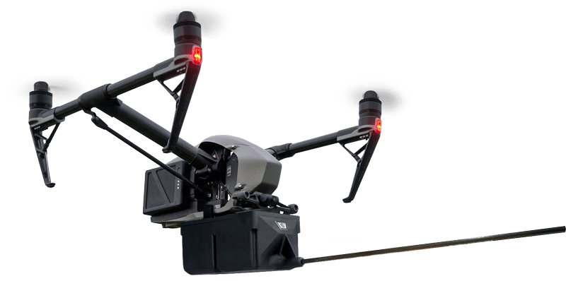
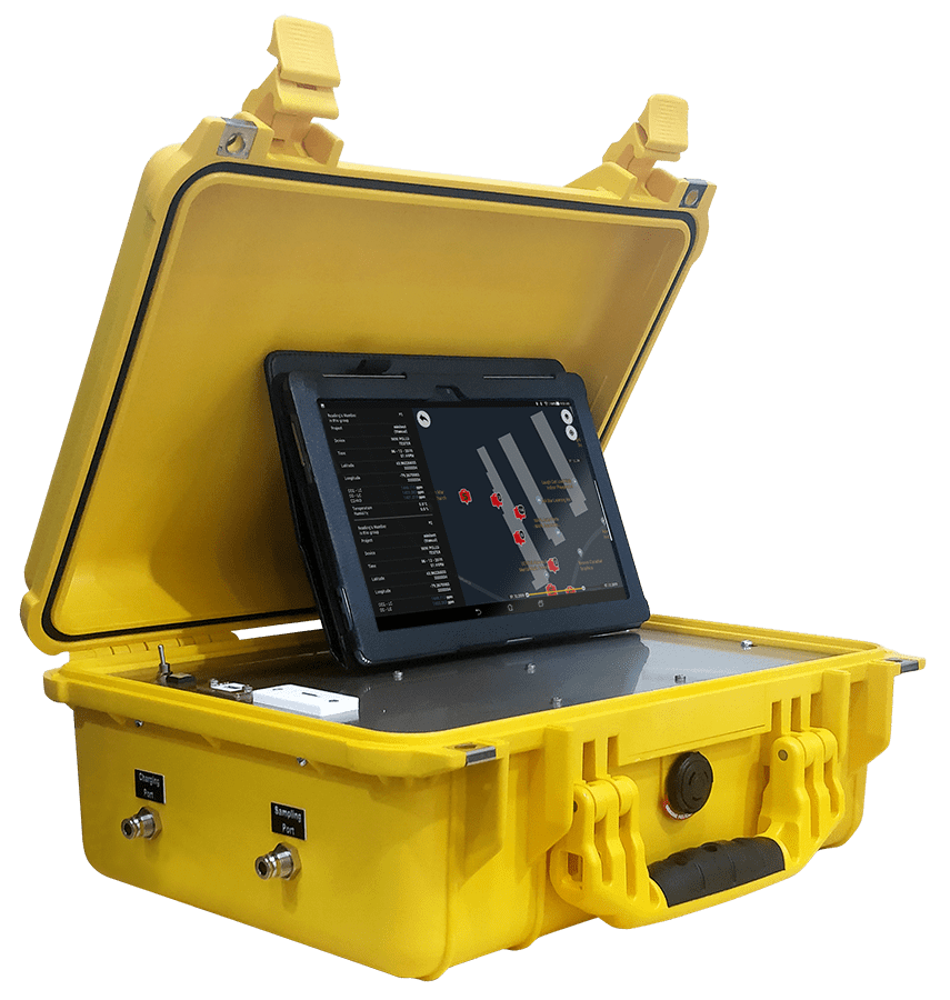
DR2000 Air Quality Monitor can be flown into environments that are potentially dangerous to personnel, such as harmful contaminants, flare plumes up to 40C or hard to access areas, either vertically or horizontally, for direct sampling.
Natural disasters like earthquakes or flooding can lead to toxic gas from chemical plants being released to the community and residences. With the high accuracy of chemical analysis, first responders can send warning or evaluation to nearby residence shortly after the event.
We also provide monitoring services and training to ensure wood burning fireplaces are operating lawfully and not emitting dangerous chemical compounds.
For wildfire smoke monitoring, learn more here.
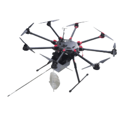
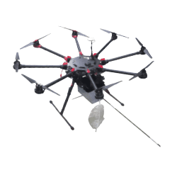
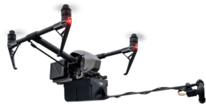
Drone-Based Air
Chemical Analyzer
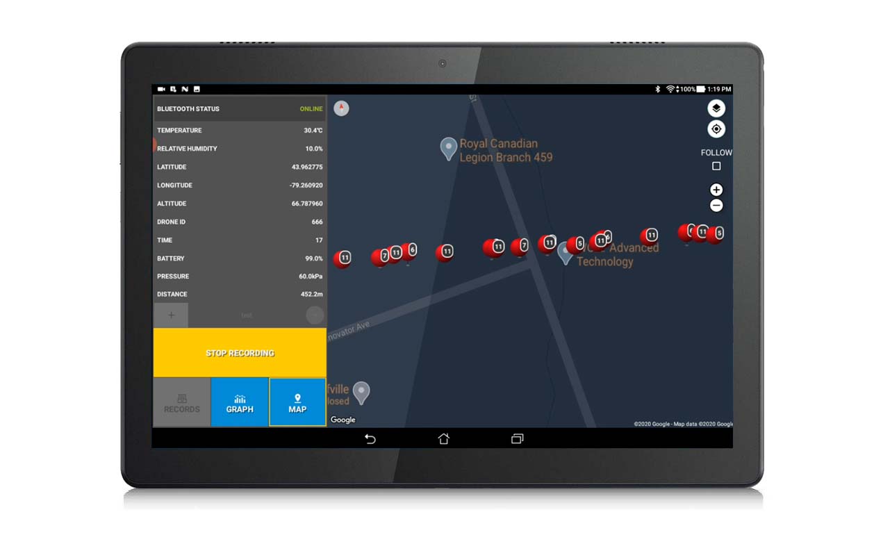
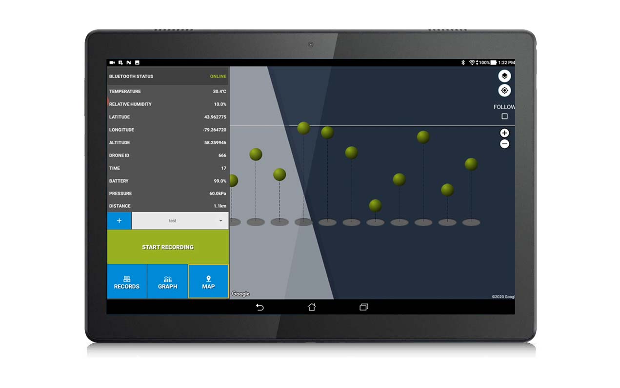
Our drone-based analyzers are enabling the detection of hot-spots and hard-to-reach areas, along with providing more granular data on the spatial and temporal patterns of the smoke. During the flight, review the real-time data deployed on our ground station.
Operator can activate our integrated Sample Acquisition System to simultaneously collect Air Samples during flight for future lab analysis.
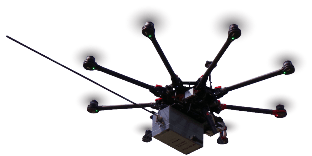

Our drone-based air quality monitors can do an instant analysis on-site and capture air for a detailed lab analysis.
Be Proactive, Not Reactive! Drone-Based analyzer can potentially save the communities near hazardous event.
Complete your air chemical assessment by bundling with our drone-based analyzer accessories!
Fine particles (PM2.5) represent the main health risk from wildfire smoke which aren't visible to the human eye.
Drone-Based Analyzer Accessories
Integrated Weather Station is an advanced technology device that measures wind speed up to 150 MPH with ambient temperature compensation. Wind speed data will help determine the direction and spread of the pollutant. It plays an important role in the rescue plan.
For fire events or wildfire, Integrated Thermal Camera on the drone-based analyzer can pick up signs of fire and identify the location of the fire.
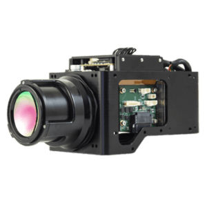
THERMAL CAMERA
Looking for Signs of Fire
When there’s potentially a high exposure chance of smoke, DR2000 with Thermal Imaging Camera will measure surface temperatures by interlacing infrared camera stills into video format.
If the odour data shows a high concentration of wildfire smoke and the image shows a high temperature surface, user can pick up signs of fire immediately.
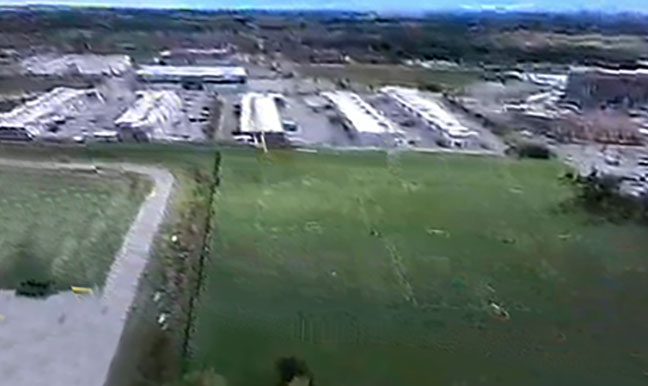
Before
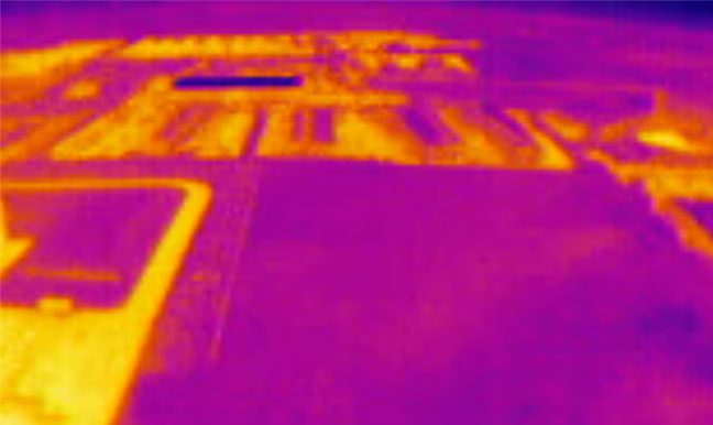
After
Hand-Held Mobile
Chemical Analyzer
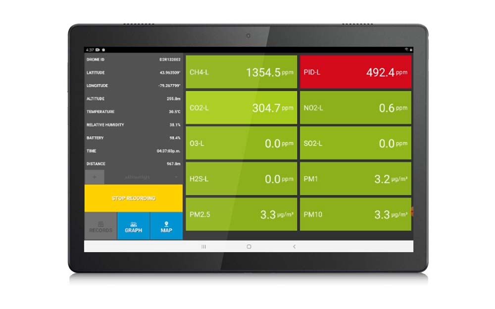
During the fire event, if drone is not accessible, we recommend our hand-held mobile device TR8+ OdoTracker Anaylzer for chemical analysis. TR8+ can measure ambient air quality and greenhouse gas, with up to 10 sensors and tracking via GPS position. TR8+ can capture air with sample bags for lab analysis.
Let Scentroid help you with Air Chemical Analysis for Emergency Response!
DRIMS2
Drone Information Management System
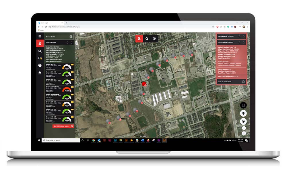
The Scentroid Drone Information Management System, DRIMS2, our all-inclusive software, is used to view historical data, run diagnostics, configure, and set alarm levels for DR2000. Provided as part of the DR2000 package, the software is installed on our on-board server (default), Scentroid’s cloud-based server (default) and on your localized server (optional).
DRIMS2 is easy to use graphical interface allows anyone to run complicated data analytics without being a GIS expert. It can control and display data from multiple DR2000s in the same fleet. Users can analyze data and monitor progress remotely from a single platform.
DRIMS2 All-Inclusive Software
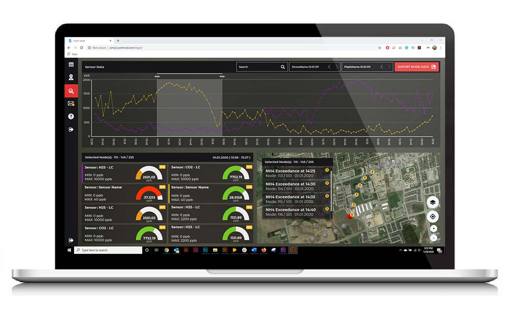
DRIMS2 provides easy analysis tools for an operator to determine pollutant hot spots, possible sources, sampled areas, and much more.
Ground Station
The Scentroid ground station consists of a specialized tablet connected to a miniature PC with a high gain powerful communication antenna. Our tablets come pre-installed with our DRIMS2 Ground Station component software. This branch of DRIMS2 software provides the user with a means to log all acquired data as it occurs. This includes all live data as well as historical data for sensors, including GPS position, altitude, temperature, and humidity.
The user can also command the drone when to take a sample and when to perform routine maintenance such as calibrating sensors. The readings are continuous, and the user can choose whether to display them live with our diagnostics feature or forward it to a database. If an optional on-board camera is present, a video feed will also be sent to the ground station for simultaneous viewing.
Analysis Software
The DR2000 comes with simultaneous GPRS and Wi-Fi communication capabilities. The GPRS is used to send data to our Scentroid cloud server. Besides using the Ground Station to communicate with our DRIMS2 system, you can also log into our secured DRIMS2 portal using any PC / laptop with a stable internet connection.
Our DRIMS2 Analysis software serves as the perfect companion to any monitoring job – an offsite wealth of information is stored in a beautiful and easy to navigate interface. After securely logging in, users can select their drone, select their flight date, favorite, name, or even search for a specific sampling node.
With access to a heat map along with viewing altitude in a 3D setting, managing a sensory project has never been easier (or more informative!).
Other Scentroid Services
Seek advice from our odour monitor experts and environmental consultants to help you improve the accuracy and reliability of your monitoring projects.
Air quality mapping, model verification, and analysis of potentially dangerous sites have all now been made possible. While in flight, built-in chemical sensors can provide remote monitoring.
Ground level readings are used by SIMS3 to conduct back-trajectory to identify smoke sources. Continuous pollution data and field olfactometric data are used along with meteorological data to triangulate the exact location of the smoke source.
Scentroid offers a complete and integrated suite for ambient air chemical analysis and odor management, known as SIMS3. Our software utilizes a unique and highly intuitive facility control system, and powerful artificial intelligence to assist you with daily tasks.
Scentroid is capable of providing you and your department with several reports ranging from SIMS3 outputs, to results based on your requirements. Several report types can be autogenerated using our SIMS3 platform.
During a wildfire, some of the smoke from outdoors can enter inside the building and make it unhealthy to breathe. Our AQmini Monitor will detect whenever a particular room’s air quality drops to below optimal levels.
Scentroid's Product
Scentroid provides a wide variety of products to assist you with air chemical monitoring on fire events or natural disasters. From drone-based anaylzers to accessories, Scentroid has you covered!
PMD100
Our portable, handheld personal monitoring device. Should an exceedance of your pre-set pollutant be found, a visual and audible alarm will trigger.
Emergency Response References
Government of Louisiana
USA
USA
Using our drone-based mobile device for emergency response such as fires and industrial accidents.
... Plus many more!
Contact Scentroid today!